|
|
|
...with Kowas Hunting Adventure Safaris
Namibia is a land of contrasts, which opens up and shines
only for those who don’t spare their effort. Namibia leads you to incredible natural
beauties and people with diverse cultures as well as historical sites, an abundance of
wildlife and the uniquely adopted flora.
|
|
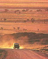
Namibia means "a place of great arid
plains" and lives up to this name. The northern parts of the
country are grass covered savannah, but the lasting impression is one of
unrelenting harshness and lack of water.
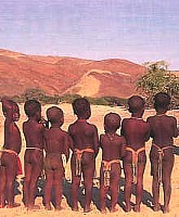
This is one of the most sparsely
populated lands on earth. San hunters, Khoikhoi and European renegades
fleeing justice in the Cape were some of the pioneers of the area.
Restless and wild, they were free from any government control until 1884
when the country was brought under the control of the German Empire.
|
|
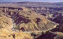 |
Second only in size to the Grand Canyon of
the USA, the Fish River Canyon is 161 km long, 27 km wide and up to 549 meters
deep.
The jagged ravine cuts deep into the arid
land. Daytime temperatures reach 48ºC and
seldom drop below 35ºC, but
nights can be very cold. The canyon is the scene of one of Africa's
finest hiking trails. As you descend into the depths of the canyon at
its northern end, civilization is left far behind, and for the next four
or five days you can experience one of the last tracts of true
wilderness on the African continent.
|
|
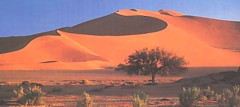 Sossusvlei is
one of
Namibia's most spectacular natural wonders. It lies about 400 km northwest of the canyon
in the heart of the Namib desert. It was opened to the public only in
1977 and is a great favorite of photographers and nature lovers. The
huge red dunes, up to 300 metres high are the largest in the world and
are an unforgettable sight at dawn or in the late afternoon sun. Sossusvlei is
one of
Namibia's most spectacular natural wonders. It lies about 400 km northwest of the canyon
in the heart of the Namib desert. It was opened to the public only in
1977 and is a great favorite of photographers and nature lovers. The
huge red dunes, up to 300 metres high are the largest in the world and
are an unforgettable sight at dawn or in the late afternoon sun.
The greatest experience of
all however, is to see the pan filled with water. This is something that
seldom occurs and photographers from all over Southern Africa will drop
everything and head for Sossusvlei for a once in a lifetime picture on
those rare occasions.
|
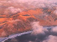 |
Although the
Skeleton Coast
can be said to encompass the entire coastline of Namibia, the Skeleton
Coast National Park is bounded by the Kunene River in the north and the
Ugab River in the south.
The early Portuguese
explorers called it "the coast of hell" but it became known as
the Skeleton Coast largely due to the dismal fate awaiting shipwreck
survivors through the centuries.
|
|
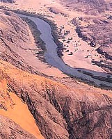
The
Kunene River forms
Namibia's northern border with Angola and is Namibia's largest river.
In ancient times the Kunene
emptied its contents into the Etosha Pan, much like the present day
Okavango in Botswana. In former years large numbers of elephant, rhino,
impala and hippo could be found here, today they have largely been
hunted out, but Willem van der Riet, the first person
to navigate the river in a canoe, reported that the Kunene crocodiles
were the largest and most fearsome that he had ever seen. |
|
|
 The
Kaokoland (or Kaokoveld) encompasses a vast arid area where the desert meets the sea
and some of the most ancient desert on earth. The
Kaokoland (or Kaokoveld) encompasses a vast arid area where the desert meets the sea
and some of the most ancient desert on earth.
Within the region
the 2586 high Brandberg mountains and
plunging river gorges, such as at Tsisab where the beautiful and
mysterious rock painting known as 'The White Lady of the Brandberg' can
be seen. Also in the region are dinosaur footprints dating from over 150
million years ago, the worlds largest known meteorite, an ancient
petrified forest and the spectacular natural sculpture known as
"Finger Klip".
|
|
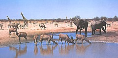 The
120 by 50 kilometer shallow pan at Etosha is believed to have
been an inland lake fed by the Kunene River before it changed its course
to reach the Atlantic Ocean. The
120 by 50 kilometer shallow pan at Etosha is believed to have
been an inland lake fed by the Kunene River before it changed its course
to reach the Atlantic Ocean.
The
edges of the pan are typical Mopane woodland, and wild game abounds.
Everything from the Big 5 to vast herds of antelope and wildebeest can
be seen in the park. There are several lodges and tourist camps in the
area catering to every taste and budget. |
|
Continue
The Tour >>>
|
|
|
